Technical Information
Land West of Dennington Road, Framlingham
The proposals have been informed by a suite of technical assessments and pre-application discussions with the relevant statutory and technical consultees.
Developer Contributions – The education authority, NHS, and other relevant District Council and County Council service providers will be consulted during the application process. Appropriate financial contributions to mitigate the impacts of the proposed development will be secured via the Community Infrastructure Levy and a Section 106 agreement.
Drainage – The entirety of the site falls within flood zone 1; the lowest risk of flooding from rivers and the sea. The site contains small areas liable to localised surface water flooding, and this can be managed through on-site attenuation basins and controlled surface water discharge to the existing ditch network east of the site. An on-site pumping station will connect to Anglian Water sewers to the south-east of the site, subject to any required upgrades. A full Flood Risk Assessment will accompany the planning application.
Landscape – The site is located at one of the gateways into the town, and there is an opportunity to enhance the landscape in this area through new tree and hedgerow planting. The planning application will include a full Landscape and Visual Impact Assessment.
Heritage – The site is located outside of the Framlingham Conservation Area and there are no listed buildings or scheduled monuments within close proximity. A Heritage Statement will be submitted in support of the planning application.
Ecology – The proposed development will deliver a Biodiversity Net Gain of at least 10% through on-site habitat creation. The planning application will be accompanied by a Preliminary Ecological Appraisal, and the development will be required to make contributions to the Suffolk Coast Recreational Disturbance Avoidance and Mitigation Strategy (RAMS).
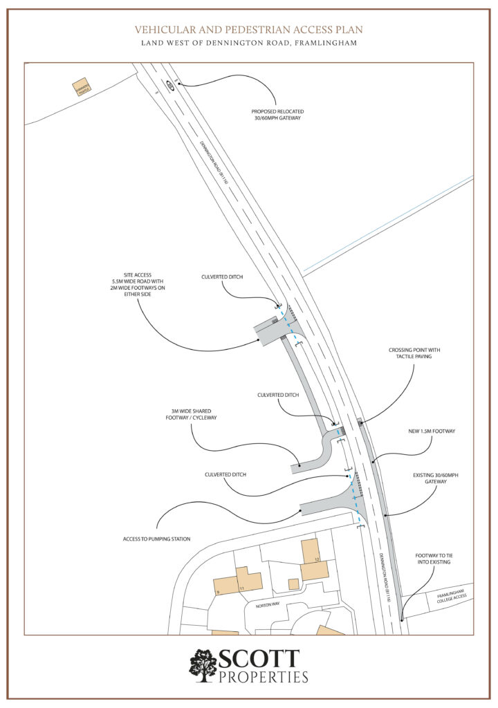
Vehicular Access – The proposed access arrangement is shown on the Vehicular and Pedestrian Access Plan below, and features a priority junction from Dennington Road comprising a 5.5m wide carriageway with 2m wide footways on either side. There is a separate vehicular access for the proposed pumping station. The existing 30/60 mph gateway is proposed to be relocated approximately 150m to the north.
Pedestrian and Cycle Access – A dedicated 3m wide pedestrian and cycle access is proposed to the south of the vehicular access. A new crossing point on Dennington Road is proposed, with a new footway along the eastern side of the road to tie in with the existing footway to the south of the access to Framlingham College. Public footpath 5 would be diverted to run inside the western boundary of the site, creating additional points of pedestrian access from the south and the north.
Select the image below to open the Vehicular and Pedestrian Access Plan (opens in a new tab).